 |
| Buzzards Roost Trail at Pfeiffer Big Sur State Park. It's a 2.6-mile loop trail through redwoods to an ocean overlook. |
 |
| The Big Sur Roadhouse is the restaurant at Glen Oaks, which offers motel-type rooms and individual cabins in the heart of Big Sur. This is where we stayed. |
When people talk about the West Coast, they often mean Los Angeles or San Francisco or even Portland, Oregon, or Seattle. But the West Coast is first and foremost a coast, complete with pounding waves, rocky outcroppings, seaside cliffs, rocky and sandy beaches and more. Parts of the coast seen as one drives California Route 1 north from Morro Bay in San Luis Obispo County to Monterey in Monterey County resemble the Cornish coast as seen in the PBS shows "Doc Martin" and "Poldark." (The landscape is similar farther north, especially in Mendocino and Humboldt counties.)
In June 2021, Jane and I drove from our home in San Diego to Healdsburg, an inland wine town in Sonoma County. Another post deals with the entire trip. Much of our time was spent along this isolated stretch of California Route 1. Head north from Morro Bay and, just past the tiny communities of Harmony and Cambria, you're committed to more than 80 miles of a two-lane road that often clings to the sides of mountains or seems suspended above canyons and ocean. It's the sort of road that, if closed to other traffic, would be great for unwinding the new mid-engine Corvette or any number of other roadsters. With traffic, though, it can be a slow slog, but a beautiful slog. Much of this area is part of Los Padres National Forest and thus protected from over development: no subdivisions, no shopping centers, no strip malls, few places to buy gasoline and relatively few places to eat and sleep. But plenty of things to see.
Before you leave San Luis Obispo County, stop about four miles north of William Randolph Hearst's famous "castle" to see an elephant seal rookery. We stopped here on on a previous trip that included Hearst Castle, which is a testament to how money can be wasted. There seem to be at least some elephant seals at the rookery all year.
The road from the county line up to the Carmel River was in 1966 designated as California's first official scenic highway (Lady Bird Johnson was on hand for the ceremony). Once you cross into Monterey County, pay attention to the ascending mile markers. Around marker 30, you'll travel over a huge berm that allowed the road to be rebuilt after a landslide wiped away a portion of the road in early 2021. At marker 36, look for Julia Pfeiffer Burns State Park. (She was a member of a pioneer family whose name appears throughout the region.) The iconic attraction here is McWay Waterfall, which can be seen after a short and easy hike. It falls 80 feet to a beach, and at the highest tides it falls directly into the Pacific. Once you've paid the $10 per car admittance to the park, you get a tag for your windshield that will get you into other parks for the rest of the day.
There's no signage to Partington Cove, so look for cars parked near marker 38. It's a short hike from the west side of the highway down a fire road to the mouth of Partington Creek, but before you get there you can take a trail that branches off on the left and goes through a 60-foot tunnel (used by the loggers more than a century ago) to a rocky cove.
Around marker 45, look for a road on the west side. A sign says "Narrow Road: No RVs or Peds." That's the clue that it's the way to photogenic Pfeiffer Beach, which charges $12.50 a car for parking (this is not part of the state park system). No RVs, but the popular Mercedes Sprinter van can make it to the beach. Here you can get your feet wet, though swimming and even wading are considered dangerous. This is a sandy beach (the sand can appear purple due to manganese garnet) with formidable rock formations in the surf.
Keep going north on Route 1 to Pfeiffer Big Sur State Park near marker 47. It's home to the one ADA accessible trail in the region (with a bridge over the Big Sur River), as well as some more challenging hikes.
Continue north on Route One and you're in the unincorporated village of Big Sur, which consists mainly of a few miles scattered with a handful of shops, restaurants and lodges. Places to stay range from state park and private campgrounds all the way up to almost $3,000-a-night or even $4,000-a-night rooms at Ventana Big Sur or Post Ranch Inn. We stayed three nights at the relatively modest Glen Oaks, giving us two full days to explore state parks and even drive through Pebble Beach. Actually, three weeks might not be long enough to do justice to Big Sur. The trees, the mountains, the ocean and the Grateful Dead on every restaurant's play list.
North of Glen Oaks is Andrew Molera State Park, which we did not visit, though another couple told us they hiked barefoot there after taking their shoes off and leaving them behind to wade through water.
Possibly the best of all the state parks in Monterey County is Point Lobos State Natural Reserve, almost all the way up Route 1 to Carmel. It's just south of Carmel River State Beach. You can join the locals parking for free on the highway or pay the $10 (or use the windshield tag you got that day at another state park) and park inside the reserve. You'll find more than a dozen trails, the longest of which is the six-mile perimeter hike. Trails like Sea Lion Point and North Shore offer great views of Point Lobos's many coves and the sea lions, seals and sea otters that live there. Between December and May, grey whales surface and dive within sight of the reserve.
If you've ventured to Point Lobos, you're only minutes away from the famous golf courses at Pebble Beach. This super-rich enclave is open to the public for $10.75 a car, which admits you to the Seventeen Mile Drive, which threads its way through blocks of private homes the size of hotels and past some of Pebble Beach's half-dozen or so golf courses. The story is that the golf courses pay for environmental projects at Pebble Beach, which is interesting since fertilizers, non-native grasses and herbicides used by golf courses make golfing an extremely un-eco-friendly sport. Nevertheless, there's a nice beach and several nice vista points on the drive, though frankly I felt quite ripped off long before we finished the drive.
North of Pebble Beach is Monterey, which we found less than enchanting except for its marvelous aquarium. The best of Monterey County is to the south, at Big Sur.
I had been aware of Big Sur for a long time, understanding it as some sort of New Age destination, probably with shops selling crystals and shamans offering to salve your soul. In reality, it is a sublime place, a succession of bluffs and headlands presided over by giant redwoods, shaded by Monterey cypress and sliced by fingers of the sea. Wisps of clouds blow through the tress, Steller's jays poke around human habitats, woodpeckers peck. And you simply breathe.
Here are some photos:
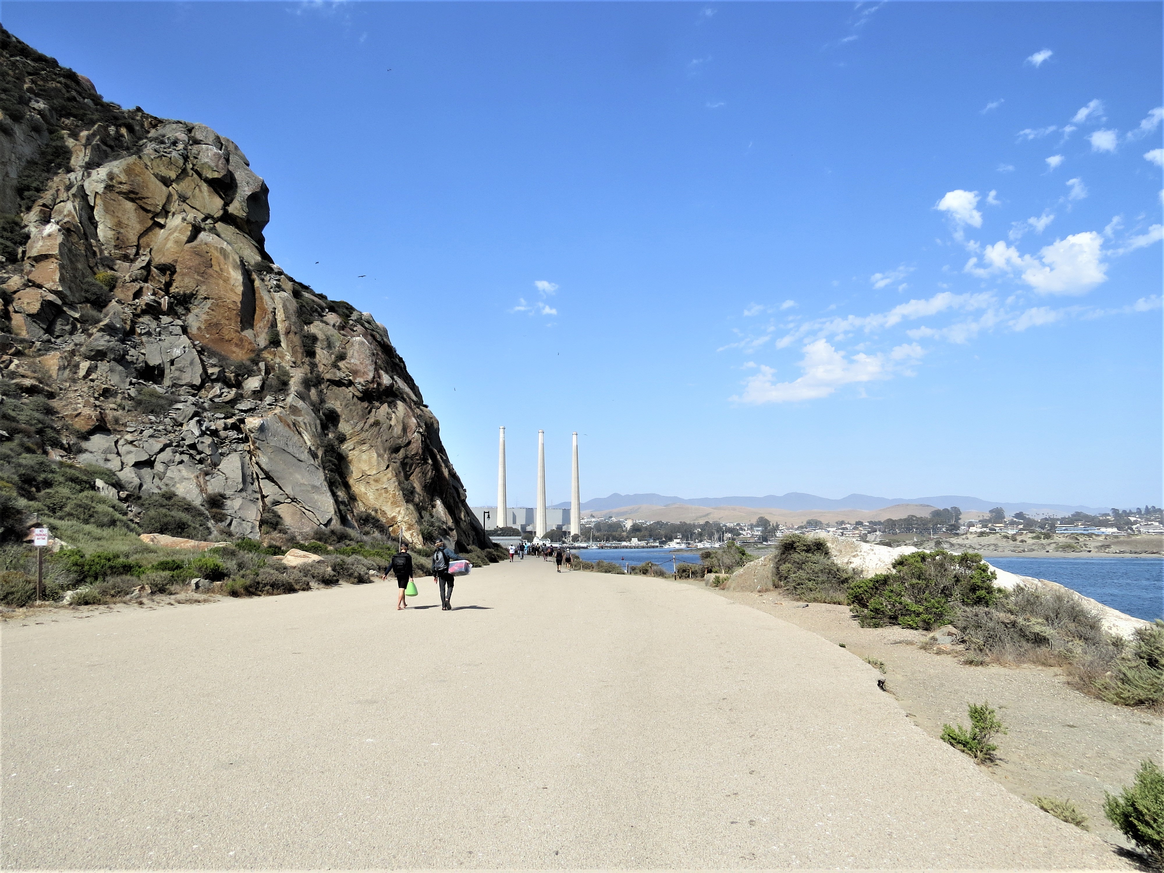 |
| Morro Rock and the smokestacks of a closed power plant are landmarks at Morro Bay. |
 |
| A wide sand beach stretches north from Morro Rock (the town is to the south and east). With water temperatures in the 50s and 60s Fahrenheit, wet suits are common, though kids seemed happy to splash around in swimsuits. |
 |
| Parked cars along Route 1 are a sure sign of a trailhead or some other attraction. |
 |
| Only adult male elephant seals have the proboscis that gives the species its name. |
 |
| I think these are females. The elephant seal rookery has good signage and a large parking area. |
 |
| The McWay Waterfall trail from the Julia Pfeiffer Burns State Park parking area takes you under Route 1. |
 | |||||||
| McWay Waterfall is a rarity among waterfalls because, at the highest tides, it falls 80 feet directly into the Pacific. I guess that incoming waves and tides replenish the sand that otherwise would be washed away where the water hits.   more than a century ago.  At the end of the trail, a rocky outcropping overlooks Partington Cove.
|


I'm glad to see the great detail here!. Please visit my site to find information about Boat tour, Snorkeling tours, what watching tours and many more at, Kauai snorkeling tours
ReplyDelete