Death Valley, which has recorded some of the hottest temperatures ever on earth, seemed like a good winter destination. Early spring and late fall would probably also work. We spent three nights in February 2024 in Furnace Creek at the Oasis Inn. Overnight lows dropped into the low 40s Fahrenheit and daily highs were in the upper 60s. It seemed like the ideal time to be there.
We drove here from Joshua Tree in our new electric car, a Hyundai Ioniq 6, stopping to recharge and have lunch in Baker, California. The charging station had a dozen Electrify America charging stations (which we use) and more than 40 Tesla stations. An EV oasis, you might say. The Oasis Inn has two free Level Two (slow) chargers and there are four others a mile away at the Oasis Ranch.
Unless you're driving a motorhome or camping van, there are few places to stay in Death Valley. The Inn and the Ranch, which have the same owner, seem like the best options, though a recent storm (which famously created temporary lakes in the valley) had caused problems at the Inn, leaving it without a working heating system and other HVAC problems. The wing where our room was had a musty smell that the constantly running fan could not eliminate. The views from the Inn, however, are incredible, as is its garden. We didn't use it, but the pool looked good, too. And the lack of heat meant the room was chilly but not unbearably cold. The Inn didn't not alert us to the heating problem until we asked about it.
Once you have shelter in Death Valley, turn your attention to food. In Furnace Creek, which can be thought of as downtown Death Valley, there are the Inn, the Ranch, a gas station and little else. The Inn has one dining room and doesn't serve lunch. The Ranch has a saloon (with burgers at lunch, steaks at dinner), an ice cream shop, a general store and a buffet-style restaurant. You need reservations for dinner but lunch seems easier. You can also pick up grab-and-go sandwiches at the general store.
Once you get out and explore beyond Furnace Creek, you'll experience one of the most exotic landscapes on earth. Much of it looks like photos sent back to Earth from NASA's Mars Rover. Colors change from bits of blinding white at Harmony Borax Works and the salt crystals of the Devil's Golf Course, to mellow golds at Golden Canyon, cliffs of rusty orange, and every shade of gray and taupe at Zabriskie Point.
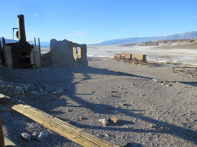
I recall watching as a child a TV show called "Death Valley Days," a long-running (1952 to 1970) syndicated Western anthology centered around Death Valley and sponsored by 20 Mule Team Borax. For a few years in the 1960s it was introduced each week by a minor Hollywood actor named Ronald Reagan. I was surprised to learn at Death Valley that the borax mining period was little more than a few years in the 1880s and then production moved to more accessible areas. The 20 mule teams, though, were real. We saw a preserved multi-wagon borax transporter at Harmony Borax Works.
Zabriskie Point is named for Christian B. Zabriskie (1864-1936), the general manager of the Pacific Borax Company (maker of 20 Mule Team products) who promoted tourism in Death Valley. Zabriskie Point was the setting for some scenes in the 1970 movie of the same name, a counter-culture effort that shows up on lists of the worst movies ever made. The point itself is very popular. It's basically a scenic overlook up a short paved walkway close to California Route 190, the valley's main road. It looks out over mud-colored hills and rocks. A trail connects it with Golden Canyon, which is otherwise accessed miles away on another road.
Although our hotel had satellite Internet, TV and wi-fi, there is little or no cell service in most of the valley, and your phone or your car may not be able to guide you. Get maps, and notice that some of the roads are not suitable for all cars. Capable four-wheel-drive vehicles can be rented in Furnace Creek, and if we had done that, we might have not had to turn around before reaching Mosaic Canyon. Some roads are marked on maps as "require experienced four-wheel drivers." I spoke with one man driving his own super-high-clearance Jeep and he said he had given up on some roads because the ruts were just too jarring.
Besides the apparently permanent terrible condition of some roads, the recent storms had done enough damage that roads were closed to some of the best-known attractions: Dantes View, Artists Drive and Artists Palette. Nevertheless, we got to see a lot and experience a lot in Death Valley.
Here are some photos:
 |
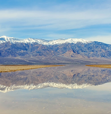
| Snow-covered mountains were visible from almost any point in Death Valley. |
 |
| The Rim Trail at Ubehebe Crater. The crater is on the right. The dark spot in the distance is the parking lot. |
 |
| Watch your step! The trail and the crater's edge are gravel. |
 |
| This once was a paved road, but the trail through Golden Canyon feels like a the bed of a dried-up stream. Much of the rock has a chalky color and feel. |
 |
| Iron deposits probably account for the red tones in the distance. |
 |
| The Golden Canyon Trail begins as an easy walk on a stone-lined path. |
 |
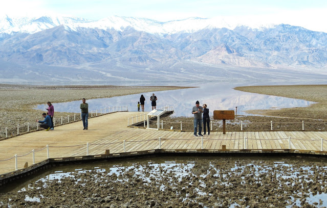
| The water in the foreground is the result of rain that fell shortly before our visit. The people on the decking are looking at Badwater Basin's permanent pool. |
 |
| This sign is embedded 282 feet high in a cliff across the road from Badwater Basin. |
 |
| The view from Zabriskie Point. Much of the landscape looks like dried mud but is rock of many different types. |
 |
| As in much of Death Valley, visitors at Zabriskie point are not restricted to trails. If you see a rock, you're welcome to climb to the top of it. |
 |
| The trail begins downhill from Zabriskie Point. |
 |
| This is one of the wagon trains once pulled by large teams of mules. Water for the animals was carried in the tank at left. The team was hitched to the right end. |
 |
| A veranda off our room at the Oasis Inn offered views of the hotel's gardens as well as endless mountains and desert. |
 |
| The guestroom wings at the Oasis Inn are one-room deep, with verandas on the other side and a hallway on the side shown here with windows that open onto the gravel-like hill that the inn is built into. |
 |
| The fan palm is the only palm tree native to California. |
 |
| More fan palms in the garden at the Oasis Inn. |
 |
| There are a couple of natural-looking pools in the hotel's garden in addition to a swimming pool. |
 |
| A tunnel leads from the hotel's basement to its parking area. It feels like the lair of a Bond villain. |
 |
| That's a prickly pear margarita on the left and a Negroni on the right. The Oasis Bar has mixologists worthy of the location. |


.jpg)


No comments:
Post a Comment